


Located at the tip of the Atsumi Peninsula, if you go to Ise by sea from here, it will be a shortcut.(渥美半島の先端に位置し、ここから海路で伊勢へ行けば近道となる。)
Irago | 伊良湖

サムライチャンプルー #13 暗夜行路 其之壱
Fuu: “Someone told me to take a shortcut!”
Mugen: “Shut up, we are okay!”
Fuu: “What’s okay?”
Mugen: “It smells, the sea.”
フウ:「誰かさんが “近道” しようなんて言うから~!」
ムゲン:「うっせえなぁ、大丈夫だよぉ!」
フウ:「なーにが大丈夫なのよぉ。」
ムゲン:「匂うんだよ、海がな。」
Samurai Champloo #13 Misguided Miscreants (Part 1)
サムライチャンプルー #13 暗夜行路 其之壱
What Mugen called a “shortcut” is the sea route that crosses from Irago cape on the Atsumi Peninsula to Ise province, but not the land route that goes directly to the the fifty-three Stations of the Tōkaidō.
ムゲンは、そのまま東海道五十三次を行く陸路ではなく、渥美半島の伊良湖岬から伊勢に渡る海路を指して、“近道”と言ったものと思われます。
The location of episodes #13 and #14 is Irago-chō, Tahara City, Aichi Prefecture, located at the tip of Atsumi Peninsula.
第13,14話の舞台は、渥美半島の先端に位置する、愛知県 田原市 伊良湖町です。
* The target on the map is set to Koiji-ga-hama Beach.
※ 恋路ヶ浜に目標を合わせた地図になります。
Cape Irago | 伊良湖岬
From here, Fuu’s party deviates from the fifty-three stations of the Tōkaidō and proceed to aim for Kansai by sea.
ここから、フウ一行は東海道五十三次から逸れ、海路で関西を目指します。
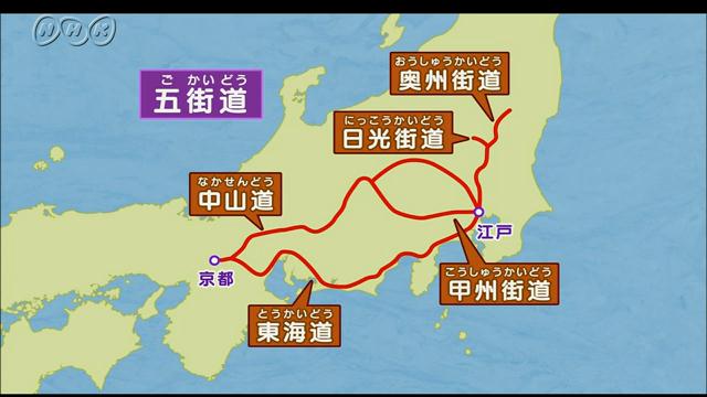
The Fifty-three Stations of the Tōkaidō refers to 53 lodging towns on the Tōkaidō, one of the Edo Five Routes constructed during the Edo period.
※ 東海道五十三次とは、江戸時代に整備された五街道の一つで、東海道にある53の宿場を指します。
出典:NHK for School
The Tōkaidō was considered to be the most important transportation route connecting Edo with Kyoto and Osaka.
東海道は、江戸と京都・大坂間を結ぶ最重要交通路とされていました。
During the Edo period, Irago belonged to Sanshū (Mikawa Province).
江戸時代、伊良湖は三州(三河国)に属していました。
* Sanshū is one of the provinces of Japan under the centralized government system called Ritsuryōsei, another name for Mikawa Province, and refers to the eastern part of Aichi Prefecture today.
※ 三州とは、三河国の別称で、日本の令制国の一つです。現在の愛知県東部を指します。
On the opposite shore was Seihū (Ise Province).
対岸には、勢州(伊勢国)がありました。
* Seihū is one of the provinces of Japan under the centralized government system called Ritsuryōsei, another name for Ise Province, and refers to the area mainly around Mie prefecture today.
※ 勢州とは、伊勢国の別称で、日本の令制国の一つです。主に、現在の三重県の辺りに該当します。
Is it really a shortcut?
本当に近道なのか?

Google Maps
As I checked on the map, the sea route is certainly a shortcut in terms of distance.
地図上で確認したところ、距離的には海路の方が確かに近道です。
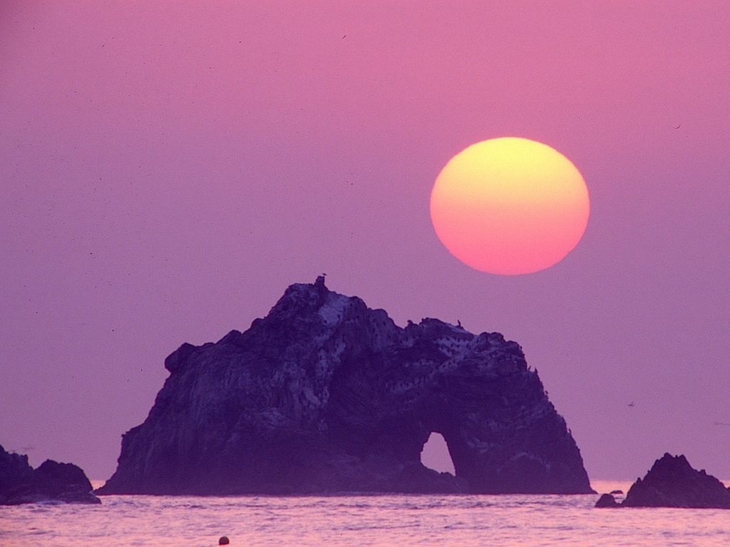
Koiji-ga-hama Beach | 恋路ヶ浜

出典:Wikipedia『渥美半島の南西端の恋路ヶ浜と伊良湖岬』
Koiji-ga-hama Beach is a sandy beach of about 1km from Cape Irago, the tip of the Atsumi Peninsula, to the nearby “Hinoi no Sekimon(Stone gate of sunrise)”.
恋路ヶ浜は、渥美半島の先端、伊良湖岬から付近にある『日出の石門』までの、約1kmの砂浜です。
出典:ニッポン旅マガジン『日出の石門』
* Atsumi Peninsula is a peninsula extending from the southeastern tip to the west-southwest of Aichi prefecture. The total length is about 50 kilometers and the width is 5-8 kilometers. In the same Aichi prefecture, it sandwiches Mikawa Bay like a “crab claw” with the Chita Peninsula extending from north to south. Most of the peninsula is occupied by the entire Tahara city, and part of the eastern part is in the southwestern part of Toyohashi city.
Wikipedia
※『渥美半島』は、愛知県の東南端から西南西に突き出すように延びている半島です。全長は約50キロメートル、幅5 – 8キロメートルと細長い。同じ愛知県で南北に延びる知多半島と「蟹のツメ」のように三河湾を挟んでいる。半島の大半を田原市全域が占め、東寄りの一部は豊橋市の南西部に当たる。
引用:Wikipedia

出典:渥美半島観光ビューロー
It seems that the origin of the name “Koiji-ga-hama(Beach of Love Road)” is a Japanese poem written in 1808 during the Edo period.
『恋路ヶ浜』という名前の由来は、江戸時代の文化5年に詠まれた和歌だそうです。
春さめに ぬれてひろはん いらご崎
恋路ヶ浦の恋わすれ貝
Translation: Let’s pick up a shellfish that forgets the pain of love, which I don’t know where to go, while getting wet with the quiet rain in spring in Iragozaki.
(Translation: Narai, Hajime)
訳:春にしとしとと静かに降る雨に濡れながら、伊良湖崎で 行く末のわからない恋の苦しさを忘れるという、貝を拾おう。
(訳:楢井 肇)
A long time ago, the song was associated with the fact that men and women of noble status were banished from the city because of unforgivable love and lived in this area.
その昔、高貴な身分の男女が許されぬ恋がゆえに都を追放され、この地に暮らした事に因んでいる歌といいます。

